Click Here to
Order this information in Print

Click Here to
Order this information on CD-ROM

Click Here to
Download this information in PDF Format


Click here to make tpub.com your Home Page

Page Title: Origins and Primary Areas of Navigation, Continued
Back | Up | Next

Click here for a printable version

Google


Web
www.tpub.com

Home

   
Information Categories
.... Administration
Advancement
Aerographer
Automotive
Aviation
Combat
Construction
Diving
Draftsman
Engineering
Electronics
Food and Cooking
Math
Medical
Music
Nuclear Fundamentals
Photography
Religion
USMC
   
Products
  Educational CD-ROM's
Printed Manuals
Downloadable Books


Origins and Primary Areas of Navigation, Continued Celestial Navigation 
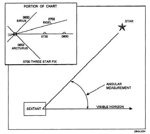
How  is  this  accomplished?  Measurements  are  taken  of  the  height  above the  horizon  of  a  celestial  body.  The  measurement  or  sight,  as  it  is commonly  referred  to,  is  then  reduced  by  a  mathematical  procedure. The  results  are  then  plotted  on  the  chart  to  determine  position  (fig.  1-2). Celestial  navigation  will  be  covered  in  greater  detail  in  chapters  6  and  9. Radionavigation Radionavigation  may  be  defined  as  the  determination  of  position  by  the use  of  radio  waves.  There  are  several  types  of  systems  in  use  today. From  the  now  seldom  used  Radio  Direction  Finder  (RDF)  to  the  latest satellite  navigation  system,  what  they  all  have  in  common  is  that  they use  radio  waves.  This  area  of  navigation  is  now  sometimes  referred  to as  electronic  navigation. This  subject  matter  will  be  covered  in  greater detail  in  chapter  8. Figure  1-2.  Sextant  angle  and  sample  3  star  fix. 1-5

Privacy Statement - Press Release - Copyright Information. - Contact Us - Support Integrated Publishing

Integrated Publishing, Inc. - A (SDVOSB) Service Disabled Veteran Owned Small Business