| |
How to Plot a Position
How to Plot a
Now that we understand the latitude and longitude scales, we can learn
Position
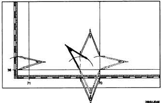
how to plot a position. We can quickly and accurately plot any known
position. Figure 1-14 will help illustrate this process. For example, a
ship’s position at 1800 (Lat. 36° 11'N, Long. 70° 17.5'W) can be plotted
as follows:
Step
1.
2.
3.
4.
5.
6.
Action
Find the latitude, 36° 11'N, on the latitude scale.
Place the point of the compass on 36° and measure up
11'; now mark the scale with the compass lead.
Without opening or closing the compass, move the point
of the compass over to the proper meridian. In this case it
is 70°. Now mark the meridian with the latitude
measurement.
Next we will find our longitude 70° and measure 17.5'.
Care must be taken to measure towards the west or left,
towards the next higher longitude. Now we will use our
lead to mark off 17.5'.
Now move the compass point up to the 36° parallel and
mark off 17.5'. Continue to move up the 70th meridian to
the point where you marked off the latitude (36°11'N) and
mark off your longitude. You will now mark off the
longitude once again, this time making a small arc.
Now place the point of the compass on the 36° parallel at
the point where the 70° 17.5' W is marked. Now mark a
small arc that will cross the longitude mark. That’s it, the
point where the two arcs intersect is the position.
How to Extract Latitude and Longitude from a Known Position
Figure 1-14. How to plot a position.
1-21
|