| |
Reference Lines on Earth
Information
To locate a position on Earth’s surface, you must first have some point
to start from. If you imagine Earth in motion, you will notice that it
spins on its axis. The axis is the imaginary line drawn between the
North Pole and South Pole that forms the first point of reference. The
second point of reference is the Equator, which divides Earth into two
parts, the Northern Hemisphere and the Southern Hemisphere.
We now have our starting points. For practical application in locating a
position, two points of reference were not adequate so we had to create
great and small circles around Earth.
Great Circles
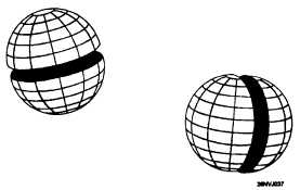
A great circle is formed by a
plane passing through the
center of Earth. Figure 1-5
illustrates our imaginary line
that connects the North Pole
and South Pole. The great
circle passes directly through
the center of Earth, but more
importantly, around Earth‘s
surface. The Equator is also a
great circle.
Figure 1-5. Examples of great circles.
Small Circles
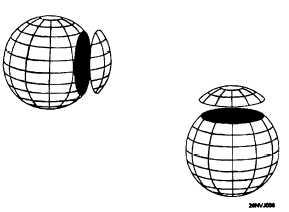
A small circle is formed by
planes that do not pass
through the center of Earth.
Figure 1-6 illustrates several
small circles. How will these
circles allow us to find our
position? The answer is that
certain great circles and small
circles have special meaning
for navigation purposes.
They are called parallels of
latitude and meridians of
longitude.
Figure 1-6. Examples of small circles.
1-9
|


