Click Here to
Order this information in Print

Click Here to
Order this information on CD-ROM

Click Here to
Download this information in PDF Format


Click here to make tpub.com your Home Page

Page Title: Earth and the Terrestrial Coordinate System
Back | Up | Next

Click here for a printable version

Google


Web
www.tpub.com

Home

   
Information Categories
.... Administration
Advancement
Aerographer
Automotive
Aviation
Combat
Construction
Diving
Draftsman
Engineering
Electronics
Food and Cooking
Math
Medical
Music
Nuclear Fundamentals
Photography
Religion
USMC
   
Products
  Educational CD-ROM's
Printed Manuals
Downloadable Books


Earth and the Terrestrial Coordinate System Background Before  we  begin  to  examine  the  nautical  chart,  we  must  first  understand some  facts  about  Earth  itself. Facts  about  Earth 
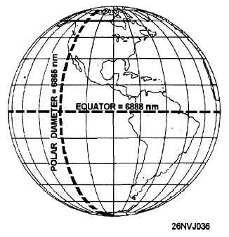
It  is  not  a  perfect  sphere The  diameter  at  the  Equator  equals  approximately  6,888  nautical  miles. The  polar  diameter  is  approximately  6,865  nautical  miles,  or  23  miles less  than  the  diameter  at  the  Equator. Technically  it  is  classified  as  an  oblate  spheroid  (a  sphere  flattened  at the poles.) Figure  1-4.  Earth. For  the  purposes  of  navigation,  we  assume  that  we  are  working  with  a perfect sphere. The  differences  between  the  two  diameters  are  small enough to be considered insignificant. Nautical  charts  do  NOT  take  Earth’s  oblateness  into  account. 1-8

Privacy Statement - Press Release - Copyright Information. - Contact Us - Support Integrated Publishing

Integrated Publishing, Inc. - A (SDVOSB) Service Disabled Veteran Owned Small Business